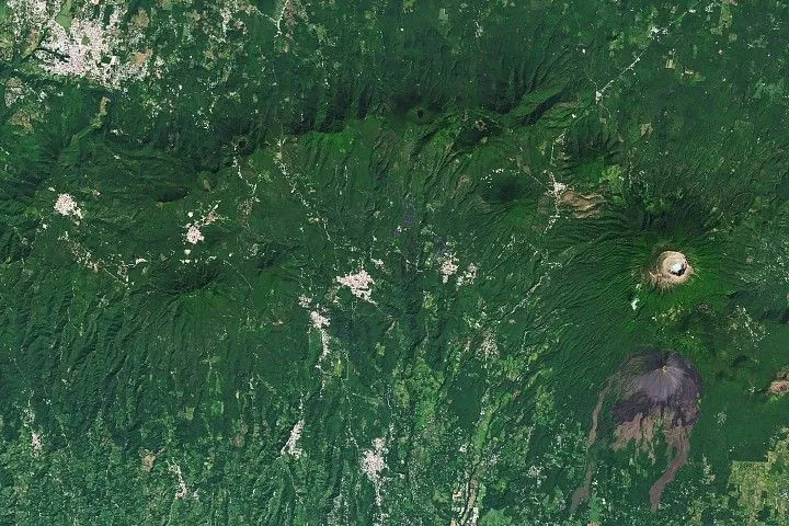
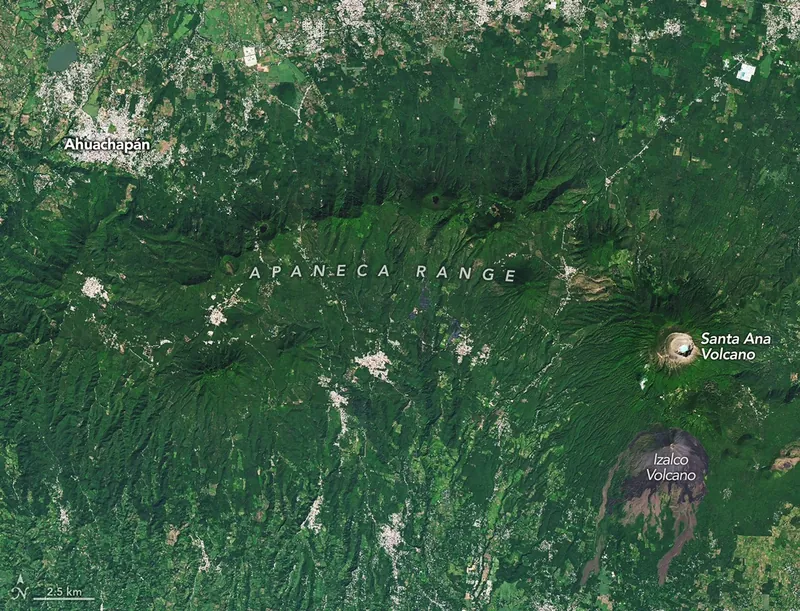
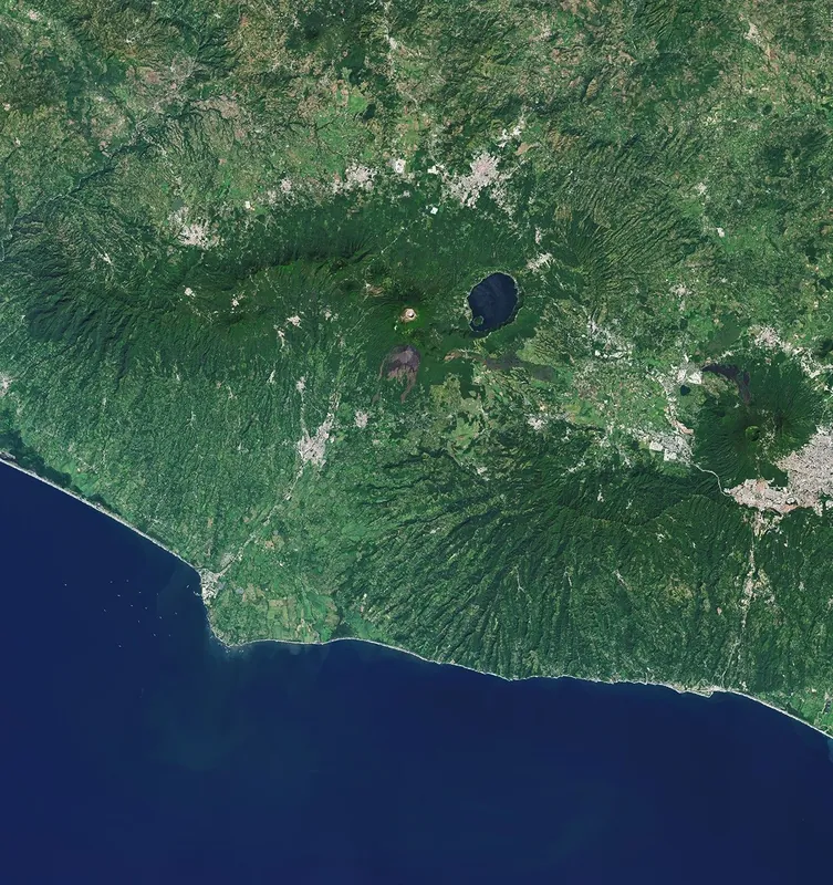
Volcanic activity takes on many forms in western El Salvador. The land near the city of Ahuachapán is pockmarked with craters and covered with recent lava flows. Meanwhile, a geothermal field feeds geysers, heats mineral pools, and powers a long-operating energy plant. The area is part of a volcanic landscape that stretches more than 1,000 kilometers (600 miles) along the Pacific coast from Guatemala to Panama, composing the Central American Volcanic Arc.
On the right side of the image, Santa Ana stands at 2,381 meters (7,812 feet) above sea level as the country’s tallest volcano. Its summit features several crescent-shaped ridges surrounding a hot, acidic crater lake. The volcano remains active, with small to moderate explosive eruptions recorded since the 16th century. Its most recent significant eruption, in 2005, launched a dense gas and ash column high in the air and sent lahars down its slopes.
In 1770, another volcano began forming on Santa Ana’s southern flank. Izalco grew into a steep-sided stratovolcano through frequent eruptions over the next two centuries. Its regular activity—including Strombolian eruptions and lava fountains—earned it the nickname “Lighthouse of the Pacific,” as people at sea were reported to witness its glowing emanations. The “lighthouse” has since powered down, with Izalco’s most recent activity occurring in 1966.
A line of forested, dimpled stratovolcano peaks arcing across the scene forms the Apaneca Range. There are no recorded eruptions of these volcanoes in the Holocene (the past 11,700 years), but persistent geothermal activity along the range manifests in the form of fumaroles, hot springs, and steam vents. Sudden and deadly steam explosions occasionally occur in the area, including a blast in October 1990 near the range’s Laguna Verde volcano. More recently, a 2025 steam eruption near a popular hot springs facility spurred evacuations and damaged infrastructure.
Though sometimes hazardous, the region’s heat source has also been tapped for geothermal power. The Ahuachapán Geothermal Power Plant has operated since 1975, leveraging groundwater naturally heated to around 250 degrees Celsius (480 degrees Fahrenheit) and local fault systems. By the early 1980s, the plant was producing 40 percent of El Salvador’s electricity. Some scholars note that this high level of production coincided with a period of civil unrest and population growth in the region.
NASA Earth Observatory image by Michala Garrison, using Landsat data from the U.S. Geological Survey. Story by Lindsey Doermann.
Downloads
November 25, 2024
JPEG (32.61 MB)
References & Resources
- Jiménez Majano, J.E. (2025) Fifty Years of Operation at the Ahuachapán Geothermal Field. Proceedings, 50th Workshop on Geothermal Reservoir Engineering.
- NASA Earth Observatory (2026, March 9) Lake Coatepeque. Accessed May 4, 2026.
- Smithsonian Institution Global Volcanism Program, Santa Ana. Accessed May 4, 2026.
- Smithsonian Institution Global Volcanism Program, Izalco. Accessed May 4, 2026.
- Volcano Live (2026, February) Apaneca Range. Accessed May 4, 2026.
You may also be interested in:
Stay up-to-date with the latest content from NASA as we explore the universe and discover more about our home planet.
Anak Krakatau Rumbles Again
3 min read
A powerful eruption from the Indonesian volcano lofted ash into the atmosphere, disrupting thousands of flights and degrading air quality.
Article
Ever Restless Mount Dukono Erupts
2 min read
The volcano on Indonesia’s Halmahera Island routinely ejects ash, volcanic gases, and volcanic bombs.
Article
Pumice Rafts Encroach on Admiralty Islands
4 min read
Buoyant volcanic rock fragments from an underwater eruption drifted across the Bismarck Sea and choked island coasts.
Article
1
2
3
4
Next
Keep Exploring
Discover More from NASA Earth Science
Subscribe to Earth Observatory Newsletters
Subscribe to the Earth Observatory and get the Earth in your inbox.
Earth Observatory Image of the Day
NASA’s Earth Observatory brings you the Earth, every day, with in-depth stories and stunning imagery.
Explore Earth Science
Earth Science Data
Open access to NASA’s archive of Earth science data
Source: NASA Science